NASA's Expanding Role in Hurricane Response
While NASA isn’t the agency issuing hurricane warnings, its behind-the-scenes work is critical in how the U.S. tracks, prepares for, and responds to major storms. As the 2024 Atlantic hurricane season progresses, NASA is once again delivering cutting-edge data to emergency responders—before, during, and after hurricanes strike.
From detailed satellite imagery to innovative modeling, NASA’s Disasters Response Coordination System (DRCS) provides state and federal agencies with crucial tools to make smarter, faster decisions.
Rapid-Response Technology in Action
During 2024’s Hurricane Helene and Hurricane Milton, NASA activated its full array of resources. Within hours of landfall, the agency was delivering:
Flood maps
Power outage data
Landslide risk assessments
These tools were accessed through NASA’s Disasters Mapping Portal, which has become a go-to resource for emergency management teams across the country.
Power Outage Detection: NASA’s Black Marble
One of NASA’s most advanced tools is Black Marble, which uses satellite data from VIIRS (Visible Infrared Imaging Radiometer Suite) to map light patterns at night.
What makes it powerful?
Neighborhood-level outage detection
Daily, calibrated observations
Used by Florida emergency crews to assess damage after Hurricane Helene, especially near hazardous sites
Unlike traditional maps, Black Marble reveals detailed insights well beyond the county level.
Flood and Landslide Risk Mapping
NASA teams also leveraged satellite radar and optical imagery from the Sentinel-1, Landsat, and Sentinel-2 missions to create real-time flood maps. These were shared directly with emergency agencies in states like North Carolina and Florida.
Landslide Monitoring:
NASA and USGS collaborated using the Landslide Hazard Assessment for Situational Awareness (LHASA) model. By integrating:
Soil moisture
Rainfall
Elevation data
They pinpointed high-risk areas across the Appalachian region, allowing early aerial surveys and warnings—even before satellites had visual confirmation.
Rainfall & Flood Prediction in Real-Time
NASA’s Global Precipitation Measurement (GPM) mission and IMERG (Integrated Multi-satellitE Retrievals for GPM) product provide near real-time, 30-minute global rainfall updates.
During Hurricane Helene:
These tools helped predict rainfall before official disaster declarations.
Flood prediction models combined GPM data with National Weather Service tools and hydrological modeling to inform early evacuations.
At NASA’s Marshall Space Flight Center, the Streamflow-AI model even forecasted flooding in small creeks and rivers—used extensively by the National Weather Service.
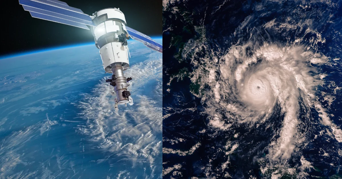
Small Satellites Redefining Hurricane Observation
NASA is also pushing boundaries with small, lower-cost satellites like those in the TROPICS constellation, which monitor tropical storms more frequently than traditional satellites.
Microwave radiometers aboard each satellite see through clouds
Tracked Hurricane Helene’s full intensification from tropical depression to Category 4
These tools provide insights into storm structure, moisture, and temperature—key for more accurate forecasting.
Compact Radar & Weather Instruments
NASA’s RainCube, a shoebox-sized satellite with radar capabilities, proved that compact sensors can match the performance of traditional full-size weather satellites.
Other ISS-Based Instruments:
COWVR: Measures ocean wind vectors
TEMPEST: Tracks atmospheric water vapor
Both are already aiding forecasters like the U.S. Joint Typhoon Warning Center.
Lightning: The Hidden Warning Sign
NASA is also researching how lightning activity inside hurricanes may signal rapid intensification. Through the Geostationary Lightning Mapper on NOAA’s GOES satellites, NASA’s SPoRT team detected a lightning burst in Hurricane Helene’s eyewall—just before it jumped from Category 2 to 4.
Understanding this link could revolutionize short-term hurricane forecasting.
The Future of Hurricane Science
As hurricane seasons become more intense due to climate change, NASA’s evolving satellite technologies and AI-driven models are critical to national safety. Its partnerships with NOAA, USGS, and local agencies turn science into life-saving action.
The data isn’t just helping experts understand storms—it’s actively saving lives.

Business Consultant | Web designer & Developer | Social media Manager | SEO | Passionate Learner, I am deeply passionate about learning and continuously improving my skills.
My interests are diverse, ranging from music and singing to computers and programming languages, digital art, AI

1 Comment
Your comment is awaiting moderation.
It’s fascinating how easily accessible modern gaming has become – the speed of verification with JL Boss 2025 sounds incredibly user-friendly! Considering the psychology of instant gratification, that quick access is key. Looking for a new jl boss slot download myself – seems promising!
Your comment is awaiting moderation.
Analyzing baccarat patterns is key, but a solid platform matters too! BossJL seems to offer a smooth experience – easy deposits & a huge game selection. Considering a bossjl app download for on-the-go play – convenience is crucial! Great article, thanks!
Your comment is awaiting moderation.
Interesting analysis! Seeing platforms like jljl boss legit focus on streamlined registration & local payment options is key for the Philippine market. User experience matters so much! Good insights here.
**men balance pro**
MEN Balance Pro is a high-quality dietary supplement developed with research-informed support to help men maintain healthy prostate function.